Displaying items by tag: Beavercreek
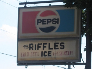
The Cherry Hill nursery once stood where the Cherry Hill shopping center now stands. Ahead on the left was Riffle’s Carry Out, a neighborhood grocer, sandwich shop and center of political debate operated by the Reid and subsequently the Hamlin families.
As you approach the intersection of Grange Hall Road, this loose-knit area was known as Concord. The northwest, pie-shaped portion of the intersection was the location of the Concord Meeting House, a church as well as Concord School #1.
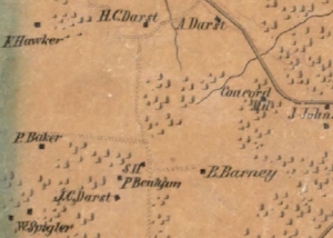
The Greene Town Center on the south side of Indian Ripple Road Was once a large orchard owned for generations by the Spigler family. The mall was completed in the mid-2000’s. On the north side is the Crestview Nursing Home, which was damaged by a tornado in 1963. Several orchards lined Indian Ripple Road as you head east on lands that were farmed by the Prugh and Benham families, both now closely associated with Kettering.
In the image above, The Greene would be located just north of P. Baker's home. Indian Ripple Road was not yet cleared, but will later connect with Grange Hall Road at the upper right of the image.
https://www.beavercreekliving.com/beavercreek-blog/itemlist/tag/Beavercreek?start=50#sigProId425e8d7191


Continue south on County Line Road to the intersection of Indian Ripple Road. Large landowners in the area during the 1870’s were the Stutsman, Real and Darst families.
A quick little aside, near the intersection of Woodman Drive and Dorothy Lane to the west of here once stood a town named Beavertown. The Beavertown Cemetery off of Valleywood Drive is the final resting place of many early Beavercreek Township settlers. Beavertown was likely the closest town for many in the southwestern part of Beavercreek Township as well as those in southeastern Van Buren Township (Kettering). If you enjoy searching for old headstones, add the Beavertown cemetery to your list.

Soon you’ll approach one of the large tracts of another respected dairy farm; a HUGE 495 acre operation owned by John Moler. You’ll find his beautiful 1856 Federal style mansion at 2544 County Line Road. Mr. Moler’s children expanded the dairy operation into Montgomery County, eventually opening Moler’s Dairy, a popular ice cream and dairy store that survived into the 1970’s!
https://www.beavercreekliving.com/beavercreek-blog/itemlist/tag/Beavercreek?start=50#sigProId43c2b3b1e5


On the east side of County Line Road you’ll find Mount Saint John, a 150-acre Marianist property where the Bergamo Center resides. The original 80 acres of Mount Saint John were Shaker lands purchased by the Marianists in 1910. The Marianist Environmental Center is an organization dedicated to increasing awareness of the Earth and natural resources by sustaining appreciation for its preservation.

Welcome to Shakertown! The Shakers were a religious sect that practiced celibacy, communal living and equality of the sexes in their leadership. The actual name of the sect was The United Society of Believers in Christ’s Second Appearing, but they became known as Shakers due to the energetic dancing included in their worship services. The community, named Watervliet, extended into both Montgomery and Greene counties and was founded by a wheelwright named John Huston.
The Shakers were significant contributors to early American life having invented the circular saw, flat broom and clothes pins. Locally they were respected as hard working, peaceful and sincere people, supporting their commune with produce farming, the packaged seed industry, and Shaker-style furniture. Their 160 acre tract in Greene County was primarily located along County Line Road at the current locations of the Mount St. John / Bergamo Center and the Research Park lands.

The northeast corner of this intersection was the location of the Dayton and Xenia Traction Power Station. Part of the building may have survived to become a portion of the Lammer's Chemical Company, also impactful to Beavercreek's more recent history - but more on that in a bit!
Please turn right at the stop sign onto Patterson Road. The field on your left was once a huge apple orchard. This stretch of East Patterson Road provides some of the most beautiful autumn colors during ‘Peak Week’ – typically late October or early November. The home at 4362 East Patterson Road dates prior to 1880 and was owned by John Moler – more on him in just a moment.
 Dayton and Xenia Traction Power Station
Dayton and Xenia Traction Power Station
Dayton and Xenia Traction Power Station
 Dayton Xenia and Belpre Railroad Stock
Dayton Xenia and Belpre Railroad Stock
Dayton Xenia and Belpre Railroad Stock
 Rapid Transit Company Transfer Ticket
Rapid Transit Company Transfer Ticket
Rapid Transit Company Transfer Ticket
https://www.beavercreekliving.com/beavercreek-blog/itemlist/tag/Beavercreek?start=50#sigProIde8b5d4c7d3
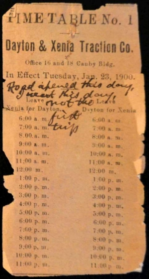
The second, and more successful mass transit line was The Dayton and Xenia Traction Company, although there were numerous owners and names that followed. We'll refer to this company as 'The Traction' as it was 100+ years ago. Carrying its first passengers on January 23, 1900, its route cut through farmland, roughly following Main Street out of Xenia to Trebein, south of the railroad tracks.
It looped to the south side of the town of Alpha, followed the train tracks to Shoup's Station and ultimately to this point (the car barn was located at the site of Lyndon's Automotive on the southeast corner), the location of the car barn and power station. From here, it proceeded west via Watervliet, Wayne Ave., Phillips Avenue and then Wyoming Street to South Main Street in Dayton.
To stop the trolley, one just stood by the side of the track and signalled the oncoming trolley with a wave of the hand.
Per Elizabeth Shoup-Belden: "January 29, 1900, the noon car on its route to Dayton had failure of air brakes when going down Phillips Avenue hill jumped the tracks at the foot of the hill. There were about twelve passengers aboard. Among the passengers were two young ladies, very close friends, who had boarded the trolley at Alpha. These two, Mill Hallie Klunk and Miss Jeanette Hagenbuch, were seated together, Hallie by the window. When the trolley left the track, Miss Klunk was thrown through the window and fatally injured. Miss Hagenbuch was miraculously saved, receiving only minor bruises.
Mr. Fred Hawker, a farmer living near Alpha, was also fatally injured. There were other serious injuries, especially the motorman, but all recovered."
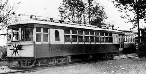
 Passenger Traction Car
Passenger Traction Car
Passenger Traction Car
 Passenger Traction Car and Barn
Passenger Traction Car and Barn
Passenger Traction Car and Barn
 Freight Traction Car
Freight Traction Car
Freight Traction Car
 View of Traction barn
View of Traction barn
View of Traction barn
 Pre-Paid Freight Coupons
Pre-Paid Freight Coupons
Pre-Paid Freight Coupons
https://www.beavercreekliving.com/beavercreek-blog/itemlist/tag/Beavercreek?start=50#sigProId11a8d05973
Turn left onto Grange Hall Road. Beyond the driveway at the south side of Carter Lumber is a long fencerow and path heading east, this was the B&O rail line. To the west it follows the 835 bypass and crosses Spaulding Road at the southern s-curve. Once over the Little Beaver Creek Bridge, pause at the stop sign onto Patterson Road.
The initial mass transit system between Dayton and Xenia was The Rapid Transit Company. In operation from approximately 1898 to 1908, this company literally operated on tracks imbedded into the compacted 'Old Route 35', now known as Dayton-Xenia Road. It left Xenia via N.Detroit Street to Fairgrounds Road, then cutting through a valley to Trebein. From there it followed Dayton-Xenia Road all the way into Dayton. An electric trolley system, the power station was located at Lucas' Grove Park, now Kil-Kare Race Park. The line struggled due to its rough road bed and eventually became unprofitable, leading to its early demise. If you'd like to tour one of the Rapid Transit rail cars please visit Carillon Park in Dayton - it's worth the price of admission!

The Little Beaver Creek parallels on the south side of the bypass and crosses to the north side just west of the I-675 underpass. In the 1870’s this area was owned by John Coy on the west and Daniel Shoup on the east.
This section of road roughly follows the former route of the Baltimore & Ohio (B&O) railway. This was a narrower gauge rail, meaning the tracks were closer together. Nearby were the tracks that accommodated the Dayton and Xenia Traction line, the second generation of trolley cars that ran from Xenia into Preble County as well as from Dayton to Troy and Springfield.
 Area Growth
Area Growth
Area Growth
 B&O Railroad Medallion
B&O Railroad Medallion
B&O Railroad Medallion
 John Coy
John Coy
John Coy
 Jed's and the Mouse That Roared
Jed's and the Mouse That Roared
Jed's and the Mouse That Roared
 Whiskey Train
Whiskey Train
Whiskey Train
https://www.beavercreekliving.com/beavercreek-blog/itemlist/tag/Beavercreek?start=50#sigProId2413bf82e7

Loose pets and stray animals are becoming an almost daily feature on the local news and social media like The Beavercreek Buzz (our favorite!). Most are innocent escapees on an exploratory mission around the neighborhood, although unlike Disney movies, sometimes forget the way home. Others, fortunately none locally, end up on the first minutes of a the five o'clock news following an attack or on a late night TV commercial with Sarah McLachlan music playing in the background.
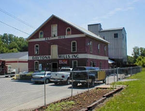
As you continue south on North Fairfield Road, you can clearly see Daytona Mills on your left. Daytona Mills continues as a business today!
Hidden in the woods immediately south of the creek is the location of the Schantz-Hagenbuch buildings just described. Turn right onto Research Boulevard/S.R. 835. At the stop sign turn left onto the S.R. 835 bypass / Research Blvd.

In 1921 the Hagenbuch’s sold the mill building to Ben Belden; he moved it piece-by-piece to the north side of the creek and switched it to electric power. The original building still stands and is known as the Daytona Mills. In the mid-1940’s, long before the development of the Coy Homestead Estates neighborhood, the original Jacob Coy cabin was purchased by Mrs. F.H. Hagenbuch and moved to their property and lovingly restored to period.

In the late 1800’s, John Schantz, who along with wife Mary bought the property in 1868, became frustrated when the mill dam, built of oak planks, broke one too many times. He abandoned the water wheel and converted the mill to steam power, channeling the excess into clumsy radiators in the house – they weren’t much to look at, but it became the first home in the area to have steam heat and shortly after, an indoor bathroom.
Near the house was a large barn; west of it stood the mill on the slope of the creek. Further west from the mill was a sawmill, and east of it was a frame building that was a smokehouse above and a springhouse below. The water is a cool 50°F and was used in the cooling of warm milk prior to use or shipment to the diaries. This building is known as the Solomon Shoup Springhouse and is the only springhouse known still to be standing in Beavercreek. Also nearby were a blacksmith shop and a carriage house.
https://www.beavercreekliving.com/beavercreek-blog/itemlist/tag/Beavercreek?start=50#sigProIdb75020b196

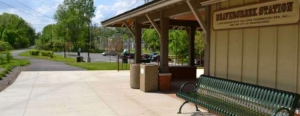
Head south and turn into the parking area of Beavercreek Station at the 9/11 Memorial. This basin was previously known as Shoup’s Station, on the Pennsylvania rail line. Just south of the tracks was the Dayton and Xenia Traction Company Line, which traversed farmlands east to Xenia and followed what is now Patterson Road into Dayton. On the east side of North Fairfield Road is an access road that crosses the Little Beaver Creek. This leads to the Schantz-Hagenbuch Home, originally a small one-room brick house which George Shoup built for his son Solomon in 1810.
George had brought his family from Frederick, Maryland in the very early 1800’s to continue his milling trade. He constructed a large three story, three stone undershot water wheel mill on the south side of the creek with a daily capacity of forty barrels. Over the years, both the Shoup and Hagenbuch families added numerous additions. An enormous fireplace had a handwrought crane that swung over the fire. The bricks were all fired on site, just west of the home.
 September 11, 2001 Memorial Dedication
September 11, 2001 Memorial Dedication
September 11, 2001 Memorial Dedication
 John Schantz Home and Mill
John Schantz Home and Mill
John Schantz Home and Mill
 1874 Map of Zimmermansville
1874 Map of Zimmermansville
1874 Map of Zimmermansville
https://www.beavercreekliving.com/beavercreek-blog/itemlist/tag/Beavercreek?start=50#sigProIdb596fda103

Lifers still refer to this area as “Push On”, but no one knows the exact history of the name. Two stories seem to be most common, the first is that farmers driving cattle from Xenia to the Dayton slaughterhouses (On Springfield Street near the former ‘Stockyards Inn’) would rest the herd near the current intersection of Route 35 and North Fairfield Road before they would ‘Push On’ to Dayton. It is also told that train and traction (more on this shortly!) conductors would ask passengers if they were disembarking or if they would ‘Push On’ to Xenia - this is the most common story.
On the east side of the downhill grade is Meadowbridge Drive. Beaver-Vu bowling alley has been a long-time favorite of Beavercreek residents - especially in the 1970's when a billiard room was constructed. Original owner Cy Grilliot was an intimidating character who would stare down patrons at the desk until they mustered the courage to ask for his assistance. His saltiness may have come from customers enjoying too many libations and then rolling bowling balls down North Fairfield Road - names withheld to protect the accused!
Behind the bowling alley is a dental office complex that was for decades the Beaver-Vu skating rink, the first in the area that didn't offer hardwood flooring.
An Imperial Grocer and Goldman's Shopping Center were also nearby.
 Beaver Vu Interior
Beaver Vu Interior
Beaver Vu Interior
 IGA Grocery
IGA Grocery
IGA Grocery
 New Businesses
New Businesses
New Businesses
 Dayton Stockyards
Dayton Stockyards
Dayton Stockyards
https://www.beavercreekliving.com/beavercreek-blog/itemlist/tag/Beavercreek?start=50#sigProId7c6db20251

The area most now consider the center of Beavercreek was long ago known as the settlement of Cimmermanville, then Zimmermanville, and later shortened to Zimmerman. The first home built here was at the southeast corner of Dayton-Xenia and North Fairfield Roads for Jacob Zimmerman, for whom the village was named. In this home was the first grocery. He also kept a house for ‘the entertainment of travelers.’
This was the second-largest town in the township to Alpha. Zimmerman School #12 sat just west of the intersection and was led by Professor Frank Zimmerman in the early days. This was a rare two-room school with the older students in the Big Room and the younger in the Little Room. Well behaved students would be awarded the honor of ringing the school bell for recess, while those not-so-fortunate would lug coal and clean the ash pan.
 North Fairfield Road
North Fairfield Road
North Fairfield Road
 Late 60's or early 70's
Late 60's or early 70's
Late 60's or early 70's
 Zimmerman School
Zimmerman School
Zimmerman School
 Zimmerman in 1874
Zimmerman in 1874
Zimmerman in 1874
https://www.beavercreekliving.com/beavercreek-blog/itemlist/tag/Beavercreek?start=50#sigProIdc46f289e27
Continue east toward North Fairfield Road. The barn at Deal’s Landscaping was built in the 1850’s by the Miller family on Hanes Road, disassembled, and moved to this location in 1988.
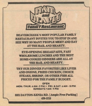
Ahead on the right was the Hail & Hearty restaurant, which started as a Hasty Tasty, Char-Burger, The Shamrock, then Mama Bear's, and later Debra Lee’s, Naomi's, Grandpa's Cafe and most recently Woody’s Barbeque. The building was demolished in 2016 to make way for an automotive repair shop and strip center.
Does anyone remember a restaurant named The Omen?
https://www.beavercreekliving.com/beavercreek-blog/itemlist/tag/Beavercreek?start=50#sigProId22e2db6e90


On Thursday, May 15, Jill Kincer, as president of the Beavercreek Historical Society, presented the Beavercreek Board of Education with a stone from the foundation of Beavercreek's first schoolhouse -- a schoolhouse built on land provided by Jacob Coy, for whom Beavercreek's Coy Middle School is named. This stone will be incorporated into the design of the district's new preschool building, which will be located on the site of the current Board of Education/Central Office Building at 3040 Kemp Road.
Mrs. Kincer's remarks to the Board follow:
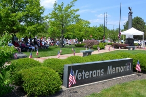
On May 26, 2014, the city of Beavercreek hosted it's annual Memorial Day Event at Veteran's Memorial Park. The event kicked off with the St. Andrew Pipes and Drums rendition of Amazing Grace, followed by a welcome and opening remarks by Mayor Brian Jarvis and the Invocation by Pastor Paul Craig.
The American Legion Post 763 posted the Colors and VFW Post 8312 raised the Flags over the event followed by the Boy Scouts leading the audience in the Pledge of Allegiance.
Latest Blog Posts
- Just Don't Call Us Late For Dinner...
- Remember When...
- What A Long, Strange Trip It's Been...
- Snow Down = Slow Down
- School Bus Safety - Just Do It!
- Stevenson Road Covered Bridge
- Our Road Crews Are Worth Their Salt!
- The Most Colorful Of Seasons!
- Popcorn Fest! - Then And Now
- Pre-School Paradise!
- Remembering Riffles
- Ten Year Anniversary Of The Beaver Statues
Featured Image


