Book
Displaying items by tag: Harbine

Turn left onto Factory Road. Beyond the sanitary plant and just past Colonial Parkway was the location of John Harbine’s oil mill. Here they would mill and press flax seed to make linseed oil, primarily used in the manufacture of early paints and stains. The flax seed residue would be pressed into cakes as fuel to burn.
It is believed the Oil Mill was located far south of town due to the strong odors emitted during the milling process. Looking closer at a high-res version of the image, one can see a man upon a buckboard wagon being drawn by 1-2 horses and another man nearby.
The 1855 Map shows the mill as being west of Factory Road, so the image would have been taken from the north looking toward Indian Ripple Road. The terrain in the image, possibly falling toward the Little Miami River, suggests the picture was taken from near Indian Ripple Road looking north. Comment below...
https://www.beavercreekliving.com/book/itemlist/tag/Harbine#sigProId8e416dd42c


Life on the south side of Alpha wasn't quite as urban. The turnpike was well to the north of town and the traction cut right through. South of the Harbine Industrial Complex the Beaver Creek was a little wider as the Big and Little merged above Shakertown Road.
Kids would often track down the creek from the 'Louis Branch' (just after the two Beaver Creeks merged) and would play at the dam, pull fish from the deep fishing holes, and kick even out the side boards of the Alpha covered bridge so that they could jump into the deep water.
Ruth Booher-Stafford's childhood home was the home south of the Harbine House on the previous page. She tells great stories of fun at 'our bridge', the Alpha bridge. One day, upon returning home from town, they noticed the bridge bowing down to the water's edge. An over-weight coal truck taking a shortcut had tried to cross the bridge and it gave way, creating a deep V in the center. The truck dumped it's load in the middle of the bridge and made it's escape up the slope. He was never caught and the bridge depicted above was torn down and not rebuilt until the Yellow Brick Road bridge you just crossed was constructed in the early 21st century.
 Ina Hartman
Ina Hartman
Ina Hartman
 Along Louis Branch
Along Louis Branch
Along Louis Branch
 Alpha Covered Bridge
Alpha Covered Bridge
Alpha Covered Bridge
 Homemade Canoe
Homemade Canoe
Homemade Canoe
 Kids At The Dam
Kids At The Dam
Kids At The Dam
 Booher Household
Booher Household
Booher Household
https://www.beavercreekliving.com/book/itemlist/tag/Harbine#sigProId6fcd4ced59

Prior to U.S. Route 35, turn left on Heller Drive and then right on Orchard Lane. Cross U.S. Route 35 and turn right on Yellow Brick Road.
The bridge over the Beaver Creek is the approximate location of Mr. Harbine’s distillery. The mill dam, just north of the existing highway, divided a mill race from the main creek. With this rudimentary dam they could control the flow to the water wheels that powered the mills. Once the mill era passed, the new leg was filled in, and is somewhat viewable in the basin on the north side of the bridge.
Construction of the US-35 highway completely altered the land as it was, but remnants of the mills can still be found just below the surface!
The Harbine Distillery was initially constructed during a time when distilling was an accepted and honored profession. Grist and saw-milling, hog raising, and pork packing were ancillary industrial concerns that made efficient use of the infrastructure and byproducts of the distilling process. Temperance and the development of a widespread and functional railroad system precipitated the decline of this industrial system by the mid-1800s. The crushing blows to rural distilling occurred during the Civil War, when federal excise taxes soared from nothing to $2.00 per proof gallon on whiskey and other distilled spirits. By 1868, when the excise taxes were finally reduced, most of the rural whiskey making ventures had either suspended production or simply ceased. The advent, operation, and demise of the Harbine Distillery parallels the once widespread rural practice of whiskey distilling, an extinct and largely forgotten feature of the American landscape.
** Below you can download a copy of 'The Distiller's Tale' - an archaeological dig at the Harbine distillery **
https://www.beavercreekliving.com/book/itemlist/tag/Harbine#sigProId251ea64e4d


As you approach U.S. Route 35, prepare to head east on Heller Drive. Ahead of you was a lane that once traversed an orchard of over 300 fruit trees! The majestic Georgian Colonial home on the cul-de-sac across the highway, appropriately named Orchard Lane, was constructed by John Harbine for he and wife Hettie in 1832. Historical accounts conflict as to whether John and Hettie lived in the log cabin at its original location during the construction of the Harbine House. It might have been moved a short distance in 1825 to what eventually became the front yard of the new Harbine residence.
The home was in the Harbine family for 117 years. A self-contained establishment, they raised grain, livestock, fruit and vegetables; they milled the grain, dried, stored and canned fruits and vegetables, butchered beef and made soap. Their cattle provided milk and butter for the family. Linen was woven from flax fiber, all onsite!
In 1944, the Heller family purchased the home and remaining 75 acres with plans to extensively improve the homestead. A few years later, the State planned a new expressway; the design would cause the razing of the Heller home. A five-year legal battle ensued with the State finally agreeing to a curve in the U.S. Route 35 to save the home. The orchard and seclusion were destroyed. Several small tracts are still owned by the Heller family.
The home was purchased by the Children’s Services Board in 1988 as a group home. It was sold in 2015 at auction to the adjacent car dealer, sealing its fate. Another, higher bid had been received at the 11th hour that would have ensured survival of the Harbine-Heller home, but was rejected by the county commissioners. The home was bulldozed in 2017. We don't know if any of the artifacts were salvaged prior to razing.
 Harbine House Front
Harbine House Front
Harbine House Front
 Harbine House Handrail
Harbine House Handrail
Harbine House Handrail
 Harbine House Scrollwork
Harbine House Scrollwork
Harbine House Scrollwork
 Harbine House Doorknob
Harbine House Doorknob
Harbine House Doorknob
 Harbine House Stair Landing
Harbine House Stair Landing
Harbine House Stair Landing
 Harbine House Threshold
Harbine House Threshold
Harbine House Threshold
 Harbine House Butler Pantry
Harbine House Butler Pantry
Harbine House Butler Pantry
 Harbine House Cellar Fireplace
Harbine House Cellar Fireplace
Harbine House Cellar Fireplace
 Harbine House Cellar Doorway
Harbine House Cellar Doorway
Harbine House Cellar Doorway
 Harbine House Cellar Door Latch
Harbine House Cellar Door Latch
Harbine House Cellar Door Latch
 Harbine House Third Level Mezzanine
Harbine House Third Level Mezzanine
Harbine House Third Level Mezzanine
 Harbine House Close
Harbine House Close
Harbine House Close
 Harbine House Plaster On Lath
Harbine House Plaster On Lath
Harbine House Plaster On Lath
 Harbine House NW Attic
Harbine House NW Attic
Harbine House NW Attic
 Harbine House SW Attic
Harbine House SW Attic
Harbine House SW Attic
 Harbine House Plaster On Lath 2
Harbine House Plaster On Lath 2
Harbine House Plaster On Lath 2
 Harbine House Trap Door
Harbine House Trap Door
Harbine House Trap Door
 Harbine House Group Home Bedroom
Harbine House Group Home Bedroom
Harbine House Group Home Bedroom
 Harbine House Porch
Harbine House Porch
Harbine House Porch
 Harbine House Parlor Marble Fireplace 1
Harbine House Parlor Marble Fireplace 1
Harbine House Parlor Marble Fireplace 1
 Harbine House Parlor Marble Fireplace 2
Harbine House Parlor Marble Fireplace 2
Harbine House Parlor Marble Fireplace 2
 Harbine House Iron Register
Harbine House Iron Register
Harbine House Iron Register
 Harbine House Steam Heat Radiator
Harbine House Steam Heat Radiator
Harbine House Steam Heat Radiator
 Harbine House Parlor Crown Mould
Harbine House Parlor Crown Mould
Harbine House Parlor Crown Mould
 Harbine House Parlor View
Harbine House Parlor View
Harbine House Parlor View
 Harbine House Ceiling Medallion
Harbine House Ceiling Medallion
Harbine House Ceiling Medallion
 Harbine House Central Staircase
Harbine House Central Staircase
Harbine House Central Staircase
 Harbine House Dining Room
Harbine House Dining Room
Harbine House Dining Room
 Harbine House Dining Fireplace
Harbine House Dining Fireplace
Harbine House Dining Fireplace
 Harbine House Stair Paneling
Harbine House Stair Paneling
Harbine House Stair Paneling
 County Commissioner Minutes
County Commissioner Minutes
County Commissioner Minutes
https://www.beavercreekliving.com/book/itemlist/tag/Harbine#sigProId169d18b4d4

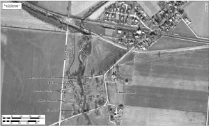
In the early 1850's John Harbine and William Needles laid out the town of Alpha along the newly built Dayton, Xenia, and Belpre Railroad. The village began to thrive when the railroad went through in 1853. A rivalry developed amongst the citizens as to who would put up the first house in the new town.
Enoch Needles and Baur Dice each began to erect their houses across the street from each other. The contest was an exciting one; and though Mr. Needles succeeded in getting the frame of his house up first, due to the rushed construction, it fell down the same night, giving Dice the opportunity of declaring that his was the first house built in the town of Alpha. Enoch Needles kept the first drygoods store in the home he built.
The undated map above shows an early map of Alpha as laid out by Harbine and Needles. Items of note:
- Dayton-Xenia Road prior to its relocation north of the school
- Alpha Church
- Beginning of the famed Alpha Panhandle
- The Dayton and Xenia Traction dips south of Alpha
- John Harbine's home
- Shakertown Road extended into Alpha
- The Shakertown Road covered bridge
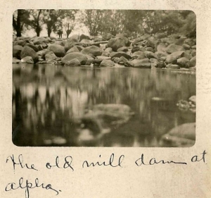
- The Alpha dam
- The mill race
- The Alpha Road covered bridge
- The Harbine worker housing
 Looking South Of Alpha
Looking South Of Alpha
Looking South Of Alpha
 Alpha Bed & Breakfast
Alpha Bed & Breakfast
Alpha Bed & Breakfast
 Barth Butcher
Barth Butcher
Barth Butcher
 Slaughterhouse
Slaughterhouse
Slaughterhouse
https://www.beavercreekliving.com/book/itemlist/tag/Harbine#sigProId757d39ee9e

It's difficult to recognize the impact that a largely vacant piece of property has had on the development and growth of a community. This area has numerous large-scale projects planned over the next decade, including the possible installation of a cloverleaf-style access to US-35. Progress destroys the physical history, as it did when the mills and structures of the Harbine Industrial Complex was torn down, but the memory and appreciation for what was remains.
Today when we think of an industrial complex, it's typically a massive operation of concrete, steel and glass. We've worked hard to collect images of the Harbine Industrial Complex to share what life and labor was like in the mid to late seventeenth century in Alpha, and ultimately Beavercreek Ohio.
https://www.beavercreekliving.com/book/itemlist/tag/Harbine#sigProIdaf47715e8a


In 1868, Harbine retired from his remaining business pursuits turning all the family business operations over to his sons Jacob, Daniel, and Frank. With John’s death in 1873 ownership of his large land holdings and businesses passed to his sons. Jacob Harbine eventually gained control of the Harbine Industrial Complex and lived with his widowed sister and her children in the Harbine House.
We'll be learning much more about John Harbine, his family, home and business ventures in the pages to come. He was truly the 'Founding Father of Alpha' and had a hand in most of the businesses in town... and even laying out the plat map for the town as well!
In 1888, a fire consumed a large portion of the complex including the grist mill, two of the worker cottages, the corn cribs and part of the distillery. The timber construction allowed the fire to spread quickly and fiercely. Locals were running a bucket brigade as well dipping their carpeting into the mill race and placing them on the roofs to prevent embers from catching more buildings on fire. This was not only their town, but their livelihood.
Ironically (or not), there was a HUGE rally of the Prohibition Party that very day in Columbus... and then the distillery caught fire. Since we love a 120+ year old conspiracy, we're looking into it!
Thelma Barth-Tindall wrote: "Mother always stopped when we took a walk to see Aunty Page, a dear old colored woman, who lived in the little cabin with the big willow tree in front of it. One time she had some pies coolin in the window and Gus was driving cattle. One cow got nosey and knocked a pie down and Aunty chased Gus up the road."
https://www.beavercreekliving.com/book/itemlist/tag/Harbine#sigProId547c9fc499

In 1855, Harbine retired from his mills, turning the operations over to his sons, in order to concentrate on real estate investments in other mills, including woolen, cotton and linseed mills throughout Greene County, as well as constructing a grain warehouse in Xenia. During this same period hog pens, a warehouse and a tobacco house were added to the Harbine Industrial Complex along Beaver Creek. He also built an oil mill on Beaver Creek with updated machinery, and switching from waterpower to steam power.
Rumor has it the Harbine’s also manufactured munitions for the Mexican-American and Civil Wars in one of the mills. If you walk back to the Big Beaver Creek, you’ll find a couple of remnants of the area’s unique history! The stone wall across the creek was an abutment for the Alpha-Bellbrook Road covered bridge that once crossed here. You’ll also notice large, scattered granite river boulders that were once part of the aforementioned Alpha Mill Dam!
Often, you'd have found pigs raised near distilleries. Alpha was no exception. There was an old tollgate house on Alpha-Shakertown Road as it came into town from the west. Having been abandoned long prior to the prime of the Industrial Complex, the cellar of the building was opened on one side and a pen constructed to raise hogs. Apparently the Harbine Hogs, as we'll refer to them, were so delicious due to their diet of dried whiskey mash that nearly all of them were sold to restaurants in New Orleans. The hogs were driven to Cincinnati and then onto New Orleans via Ohio River flatboats.

When you reach the stop sign at Factory Road, you are facing the location of The Harbine Industrial Complex. Please turn north and pull into the RV and boat storage parking lot. In 1828 John Harbine (also spelled Harbein) and his new bride, Hettie Herr, traveled by wagon from Maryland to Beavercreek Township with what money they had nailed under the axle for safe keeping from highway robbery. He purchased the 180 acre farm of Owen Davis, the first settler of Greene County. As a business entrepreneur, John began constructing his mill complex during the same period as he built his residence. The grist mill, saw mill and distillery [the core of the Harbine Industrial Complex] were operating on Beaver Creek by 1832.
On the image above, you can see where the Beaver Creek was split to utilize a mill race, a regulated channel of water to power the water wheels of the mills. The square under the P in Alpha represents the Harbine home, surrounded by a fruit orchard. Between the mill race and Factory Road are 9 dots representing worker housing for the laborers to live in.
The worker housing has become of particular interest due to proposed highway modifications. An archeaological firm was retained to do ground penetrating radar to locate the remnants of the homes as well as any evidence of the lifestyle the occupants led.
Recollections have been passed down referring to John Harbine Jr. walking the worker housing with a hand basket containing a pistol to collect rent.
In researching our tour, we learned a couple names that were attached to the Harbine worker housing including 'Shorty' Brown. In May of 2015 we met with Mr. Bill Brown, a longtime resident of the Alpha area and son of Marvin 'Shorty' Brown.
Bill's parents lived in the worker housing when he was born. He explained that there were three of the homes remaining at his earliest recollection, with one burning to the ground while he was young. Bill described the worker housing as follows:
- Four rooms - Kitchen, Living Room and two bedrooms
- Wood plank flooring over a crawl space
- Heat provided by a coal stove in the Living Room
- Meals were prepared on a wood-fired stove in the Kitchen
- Exterior was lap-board siding with tin roofs
- Interior walls were plaster-on-lath
- No interior plumbing
Bill recalled that the only water came from an outside well with a hand pump. There was one 'privy', or outhouse, for every two homes. They were located east of the buildings toward the creek. Bill's mother would heat stones on the kitchen stove, wrap them in towels and place in their beds to warm them in the winter.
In looking at the map, the Brown's lived in the second home from the north. Kiff Karns, he said, lived in the home next door.
https://www.beavercreekliving.com/book/itemlist/tag/Harbine#sigProId06dd85bfd8

Navigation
Latest Blog Posts
- Just Don't Call Us Late For Dinner...
- Remember When...
- What A Long, Strange Trip It's Been...
- Snow Down = Slow Down
- School Bus Safety - Just Do It!
- Stevenson Road Covered Bridge
- Our Road Crews Are Worth Their Salt!
- The Most Colorful Of Seasons!
- Popcorn Fest! - Then And Now
- Pre-School Paradise!
- Remembering Riffles
- Ten Year Anniversary Of The Beaver Statues
Featured Image